GEN 2 TABLEAUX ET CODES TABLES AND CODES
GEN 2.1 SYSTEME DE MESURE, MARQUES D'AERONEF, JOURS FERIES MEASURING SYSTEM, AIRCRAFT MARKINGS, PUBLIC HOLIDAYS
| 2.1.1 | UNITES DE MESURE | 2.1.1 | UNITS | ||||||||||||||||||||||||||||||||||||||||||||||||||||||||||||||||||||||||||||||||||||||||||||||||||||||||||
| La table d’unités (Table OACI) utilisée dans les publications d’information aéronautique, dans les NOTAM et les circulaires d’information aéronautique est donnée ci-après : | The units used in aeronautical information publications NOTAMs, and aeronautical information circulars are indicated in the following table (ICAO table) : | ||||||||||||||||||||||||||||||||||||||||||||||||||||||||||||||||||||||||||||||||||||||||||||||||||||||||||||
| |||||||||||||||||||||||||||||||||||||||||||||||||||||||||||||||||||||||||||||||||||||||||||||||||||||||||||||
| a) | Expression des altitudes ou hauteurs : | a) | Expression of altitudes or heights : | ||||||||||||||||||||||||||||||||||||||||||||||||||||||||||||||||||||||||||||||||||||||||||||||||||||||||||
| L’instruction 20754 DNA du 12 octobre 1982 modifiée fixe, dans son annexe 4, les règles à appliquer pour le calcul et l’expression des altitudes ou hauteurs pour l’établissement des procédures de départ, d’attente et d’approche aux instruments. | Instruction 20754 DNA of 12 October 1982, as amended, defines, in its annex 4, the rules to be applied for the calculation and expression of altitudes or heights for the establishment of departure, holding and approach procedures on instruments. | ||||||||||||||||||||||||||||||||||||||||||||||||||||||||||||||||||||||||||||||||||||||||||||||||||||||||||||
| b) | Les altitudes ou hauteurs mentionnées sur les diverses cartes aéronautiques pour indiquer des informations relatives à la topographie ou aux obstacles sont calculées : | b) | The altitudes or heights indicated on the various aeronautical charts to provide information concerning the topography or obstacles are to be calculated using : | ||||||||||||||||||||||||||||||||||||||||||||||||||||||||||||||||||||||||||||||||||||||||||||||||||||||||||
| - soit en utilisant la formule : 1 mètre = 3,2808 pieds ; | - either the formula : 1 metre = 3,2808 ft ; | ||||||||||||||||||||||||||||||||||||||||||||||||||||||||||||||||||||||||||||||||||||||||||||||||||||||||||||
| - soit par lecture de la table de conversion en GEN 2.6-1. | - or by reading from the conversion table shown in page GEN 2.6-1. | ||||||||||||||||||||||||||||||||||||||||||||||||||||||||||||||||||||||||||||||||||||||||||||||||||||||||||||
| Le résultat obtenu est publié en arrondissant au pied le plus proche. | The obtained result is to be approximated to the nearest foot for publication. | ||||||||||||||||||||||||||||||||||||||||||||||||||||||||||||||||||||||||||||||||||||||||||||||||||||||||||||
| c) | Les altitudes ou hauteurs des limites verticales des espaces aériens ou d’activités aériennes (circuit d’aérodrome, voltige, parachutisme,...) sont exprimées, lorsqu’elles doivent être publiées en pieds, en adoptant les correspondances prévues dans le tableau des niveaux de croisière publié dans le règlement de la circulation aérienne (RCA 1.51 - Appendice C) complétées, si nécessaire, par les valeurs intermédiaires usuelles suivantes : | c) | The altitudes or heights of the vertical limits of airspace or of aerial activities (aerodrome circuits, aerobatics, parachuting, etc), when they have to be published in feet, are to be expressed using the equivalents given in the table of cruising levels published in the air traffic regulation (RCA 1.51 - Appendix C), with the addition, if necessary of the following usual intermediate values : | ||||||||||||||||||||||||||||||||||||||||||||||||||||||||||||||||||||||||||||||||||||||||||||||||||||||||||
|
Mètres
(m) |
Pieds
(ft) |
Mètres
(m) |
Pieds
(ft) |
Mètres
(m) |
Pieds
(ft) | ||||
| 50 | 170 | 500 | 1 700 | 1 200 | 4 000 | ||||
| 100 | 330 | 600 | 2 000 | 1 350 | 4 500 | ||||
| 150 | 500 | 750 | 2 500 | 1 500 | 5 000 | ||||
| 200 | 700 | 800 | 2 700 | 1 700 | 5 500 | ||||
| 250 | 800 | 900 | 3 000 | 1 850 | 6000 | ||||
| 300 | 1 000 | 1 000 | 3 300 | 2 000 | 6500 | ||||
| 450 | 1 500 | 1 050 | 3 500 |
| d) |
En cas de valeur multiple publiée pour une même information
(FL / ASFC / AMSL), il convient de considérer la plus élevée des deux. | d) |
In the event of a multiple value published for the same
information
(FL / ASFC / AMSL), the higher of the two should be considered. |
| Ex 1 : | FL 115 | Ex 1 : | FL 115 | ||||||||||
| 4000 ft AMSL | 4000 ft AMSL | ||||||||||||
| 1000 ft ASFC | 1000 ft ASFC |
| Signifie : | Means | |||
| plafond = FL 115 | upper limit = FL 115 | |||
| et plancher = le plus haut entre 1000 ft ASFC et 4000 ft AMSL | and lower limit = 1000 ft ASFC or 4000 ft AMSL whichever is higher | |||
| Ex 2 : | FL 195 | Ex 2 : | FL 195 | ||||||||||
| FL 115 | FL 115 | ||||||||||||
| 3000 ft ASFC | 3000 ft ASFC |
| Signifie : | Means | |||
| plafond = FL 195 | upper limit = FL 195 | |||
| et plancher = le plus haut entre 3000 ft ASFC et FL 115 | and lower limit = 3000 ft ASFC or FL 115 whichever is higher. | |||
| 2.1.2 | SYSTEME DE REFERENCE TEMPOREL | 2.1.2 | TEMPORAL REFERENCE SYSTEM | |
| La référence au temps universel coordonné (UTC) est adoptée par le SERVICE DE L’INFORMATION AERONAUTIQUE - FRANCE dans les documents qu’il publie. | Reference to the coordinated universal time (UTC) has been adopted in documents issued by the AERONAUTICAL INFORMATION SERVICE - FRANCE. | |||
|
Sauf avis contraire, les horaires publiés dans l'AIP France sont exprimés en horaires
UTC correspondants à la période d'hiver (HIV).
Pendant la période d'hiver, les horaires légaux sont obtenus en ajoutant une heure aux horaires UTC publiés. Pendant la période d'été, il convient de retirer une heure à l'horaire publié pour obtenir l'horaire UTC. |
Unless otherwise stated, the schedules published in the AIP France are expressed in UTC schedules corresponding to the winter period (WIN). During the winter period, statutory schedules are obtained by adding one hour to published UTC schedules. During the summer period, it is appropriate to withdraw one hour from the published schedule to obtain the UTC schedule. | |||
| Si l'on prend l'exemple d'un service dont les horaires d'ouverture sont 0800-1700 en heure locale toute l'année, les horaires UTC correspondants sont : | Taking the example of a service whose opening hours are 0800-1700 in local time throughout the year, the corresponding UTC schedules are: | |||
| - pendant la période hivernale : 0700-1600, | - during the winter period: 0700-1600, | |||
| - pendant la période estivale : 0600-1500. | - during the summer period: 0600-1500. | |||
| Les horaires d'ouverture sont donc 0700-1600 (UTC) en hiver et 0600-1500 (UTC) en été, ce qui se résume en l'horaire publié à l'AIP suivant : 0700-1600 UTC (ETE : -1 HR). | The opening times are therefore 0700-1600 (UTC) in winter and 0600-1500 (UTC) in summer, which is summarized in the schedule published at the following AIP : 0700-1600 UTC (SUM: -1 HR). | |||
| Une AIC est diffusée chaque année par le SIA pour communiquer les dates de changement d'horaire entre l'heure d'hiver (HIV) et l'heure d'été (ETE). | An AIC is issued annually by the SIA to communicate the schedule change dates between winter and summer time. | |||
| Conformément aux textes réglementaires en vigueur en France métropolitaine, les organismes de l’aviation civile adopteront l’heure légale suivante : cliquez ici . | In accordance with the regulations in force in metroplitan France, civil aviation organisms will comply to the following official time system: click here . | |||
| Lorsque l’heure légale est utilisée, mention en est faite. | Whenever legal time is being used, this will be so stated. | |||
| 2.1.3 | SYSTEME DE REFERENCE HORIZONTAL | 2.1.3 | HORIZONTAL REFERENCE SYSTEM | |
| WGS-84 sauf mention contraire. | WGS-84 unless otherwise stated. | |||
| 2.1.4 | SYSTEME DE REFERENCE VERTICAL | 2.1.4 | VERTICAL REFERENCE SYSTEM | |
| 2.1.4.1 | GENERALITES | 2.1.4.1 | GENERAL | |
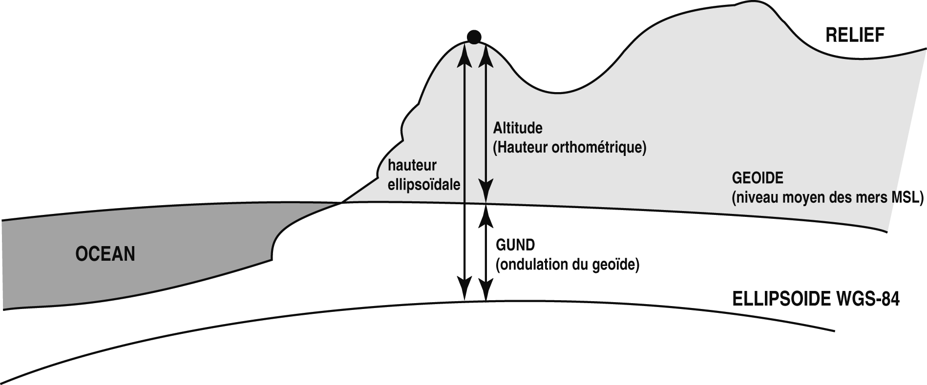
| Dans le domaine de l’aviation civile, les altitudes et les niveaux de vol sont définis par la pression atmosphérique. Les points au sol sont définis par leurs coordonnées planimétriques et par leur hauteur orthométrique ou altitude, qui a pour référence le géoïde (correspondant au niveau moyen des mers, ou Mean Sea Level). | In the Civil Aviation field, altitudes and flight levels are defined in terms of atmospheric pressure. Points on the ground are defined by their planimetric coordinates and by their orthometric height or altitude, which use as their reference the geoid (corresponding to Mean Sea Level). | |||
| Les hauteurs dérivées de systèmes GNSS ont pour référence l’ellipsoïde WGS-84, et sont donc différentes des valeurs de hauteur orthométrique en un même point. | The heights derived from GNSS systems use the WGS-84 ellipsoid as their reference and are thus different from the values of the orthometric height at the same point. | |||
| La différence de hauteur entre l’ellipsoïde (référence des hauteurs GNSS) et le géoïde (référence des hauteurs orthométriques) est appelée l’ondulation du géoïde. Cette valeur exprime donc la distance du géoïde au dessus (ondulation du géoïde positive) ou au dessous (ondulation du géoïde négative) de l’ellipsoïde de référence. On a ainsi la relation : | The height difference between the ellipsoid (GNSS height reference) and the geoid (orthometric height reference) is called the undulation of the geoid. This value thus defines the distance of the geoid above (positive undulation of the geoid) or below (negative undulation of the geoid) the reference ellipsoid. This gives us the relationship : | |||
| Ondulation du géoïde = Hauteur ellipsoïdale - Hauteur orthométrique (altitude) | Undulation of the geoid = Ellipsoidal Height - Orthometric Height (Altitude) | |||
| Le Service de l’Information Aéronautique publie la valeur de l’ondulation du géoïde pour chaque aérodrome IFR. Cette valeur, nommée conventionnellement GUND, est exprimée en pieds. Elle sera portée sur les cartes au fur et à mesure de leurs rééditions. | The Aeronautical Information Service publishes the values of the undulation of the geoid for each IFR aerodrome. This value, conventionally designated GUND, is expressed in feet. It will be shown on the charts as and when they are amended. | |||
| Note : En France métropolitaine, l’ondulation du géoïde est toujours positive (géoïde au dessus de l’ellipsoïde). | Note : In metropolitan France, the undulation of the geoid is always positive (geoid above the ellipsoid). | |||
| 2.1.4.2 | AVERTISSEMENT : | 2.1.4.2 | WARNING : | |
| L’attention des usages est attirée sur le fait que la publication des valeurs d’ondulation du géoïde ne modifie pas les restrictions d’emploi du GPS. En particulier, l’information d’altitude fournie par le GPS reste inutilisable. | User’s attention is drawn towards that publication of the geoid undulation does not modify the GPS restrictions for use. Particularly, the altitude information given by GPS has not to be used. | |||
 | ||||
| 2.1.5 | MARQUES DE NATIONALITE ET D’IMMATRICULATION | 2.1.5 | NATIONALITY AND REGISTRATION MARKS | |
| La marque de nationalité des aéronefs civils français est la lettre F. | The nationality mark of French civil aircraft is letter F. | |||
| La marque de nationalité est suivie de la marque d’immatriculation composée de 4 lettres : | The nationality mark is followed by the registration mark composed of 4 letters. | |||
| Ex : F-BHZR. | Ex.: F- BHZR. | |||
| 2.1.6 | CONGES ANNUELS ET JOURS FERIES | 2.1.6 | OFFICIAL PUBLIC HOLIDAYS AND PERIODS OF SCHOOL | |
| Les dates des fêtes légales sont publiées par circulaire d’information aéronautique (AIC) pour l’année en cours. | Public holidays dates are published by aeronautical information circular (AIC) for current year. | |||
| Cliquez ici . | Click here . | |||
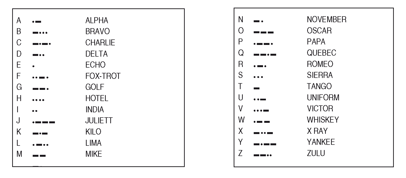
| 2.1.7 | ALPHABET MORSE | 2.1.7 | MORSE ALPHABET | |
 | ||||
|
PASSAGE DU MODELE DE GEOIDE FRANCAIS AU MODELE DE GEOIDE
MONDIAL
SWITCHING OVER FROM FRENCH GEOID MODEL TO WORLD GEOID MODEL | ||||
| 1 | DESCRIPTION DES MODELES | 1 | DESCRIPTION OF MODELS | |
| Le modèle de géoïde choisi par l’OACI dans le cadre de l’AIP est EGM96 (Earth Gravity Model 1996). Il s’agit d’un modèle mondial. Sa précision est métrique. Son pas est de 0.25° (15’). | The geoid model selected by ICAO within the scope of AIP is EGM96 (Earth Gravity Model 1996). It is a World model. Its accuracy is metric. Its increment is 0.25° (15’). | |||
| En France, il existe un modèle local de géoïde couvrant la totalité du territoire continental, nommé RAF98 (Référence des Altitudes Françaises 1998). Sa précision est inférieure à 5 centimètres. Son pas est de 0.033° (2’) en longitude et 0.025° (1.5’) en latitude. Il est compatible avec le système d’altitude NGF/IGN69. | In France, there is a local geoid model covering the whole continental territory, called RAF98 (Reference of French Altitudes 1998). Its accuracy is less than 5 centimeters. Its increment is 0.033° (2’) in longitude and 0.025° (1.5’) in latitude. It is compatible with the altitude system NGF/IGN69. | |||
| Pour la Corse, il existe un modèle local de géoïde nommé GGF97 (Géoïde Géométrique Français 1997). Sa précision est décimétrique. Son pas est de 0.1° (6’). Il est compatible avec le système d’altitude NGF/IGN78. | For the Corsica Island, there is a local geoid model called GGF97 (French Geometric Geoid 1997). Its accuracy is decimetric. Its increment is 0.1° (6’). It is compatible with the altitude system NGF/IGN78. | |||
| En un point quelconque, chaque modèle fournit par interpolation l’ondulation du géoïde au-dessus de l’ellipsoïde WGS-84. | At any point, each model provides through interpolation the geoid undulation above the ellipsoid WGS-84. | |||
| 2 | REPRESENTATION GRAPHIQUE DE L’ECART ENTRE MODELES | 2 | GRAPHIC REPRESENTATION OF THE DEVIATION BETWEEN MODELS | |
| 2.1 | Correction d’ondulation | 2.1 | Correction of undulation | |
| Les graphiques ci-dessous permettent d’obtenir l’ondulation donnée par EGM96 connaissant celle donnée par les modèles locaux RAF98 et GGF97. Ils sont issus de grilles calculées aux pas des modèles locaux. Ils représentent les courbes d’égale différence d’ondulation entre ces modèles et le modèle mondial. Cette grandeur est exprimée en mètres. | The graphic below are used to obtain the undulation given by EGM96, knowning the undulation given by local models RAF98 and GG97. They are issued from grids calculated with increments of local models. They show the curves of equal difference in undulation between these models and the world model. The value is expressed in meters. | |||
|
Pour la France : Ondulation [EGM96] =
Ondulation [RAF98] + valeur lue sur le graphique. |
For France: Undulation [EGM96] =
Undulation [RAF98] + value read on the graphic. | |||
|
Pour la Corse : Ondulation [EGM96] =
Ondulation [GGF97] + valeur lue sur le graphique. |
For Corse: Undulation [EGM96] =
Undulation [GGF97] + value read on the graphic. | |||
| 2.2 | Correction d’altitude | 2.2 | Correction of altitude | |
| Les graphiques permettent également d’obtenir l’altitude donnée par RAF98 et GGF97 connaissant celle donnée par EGM96. Ils représentent les courbes d’égale différence d’altitude entre le modèle mondial et les modèles locaux. Cette grandeur est exprimée en mètres. | The graphics are also used to obtain the altitude given by RAF98 and GGF97, knowing the altitude given by EGM96. They show the curves of equal difference in altitude between the world model and the local models. This value is expressed in meters. | |||
|
France : Altitude
[IGN69] =
Altitude [EGM96] + valeur lue sur le graphique
Corse : Altitude [IGN78] =
|
France: Altitude
[IGN69] =
Altitude [EGM96] + value read on the graphic
Corsica Island: Altitude [IGN78] =
| |||
| 3 | REPRESENTATION TABULAIRE DE L’ECART ENTRE MODELES | 3 | GRAPHIC REPPRESENTATION OF THE DEVIATION BETWEEN MODELS | |
| L’écart entre les modèles peut se représenter sous forme de grille. La ligne supérieure des tableaux ci-dessous donne la longitude des noeuds de grille, la colonne de gauche fournit leur latitude. Ces deux coordonnées sont exprimées en degrés décimaux. | The deviation between the models can be shown as a grid. The upper line of tables below gives the longitude of grid knots; the left culumn provides their latitude. These two coordinates are expressed in decimal degrees. | |||
| Pour des raisons de présentation, la France est partagée en trois zones de longitude, avec une colonne de recouvrement en limite de zone: | For presentation purpose, Francce is divided into three longitude areas, with an overlap column at the area end. | |||
|
France Ouest : de -4.75° à -0.5°
France Centre : de -0.25° à 3.75° France Est : de 4° à 8°. |
West France: from -4.75° to -0.5°
Middle France : from -0.25° to 3.75° East France : from 4° to 8°. | |||
| Le tableau relatif à la Corse a été associé avec le tableau France Est. | The table related to the Corsica Island has been associated with the “East France” table. | |||
| Pour la France comme pour la Corse, la grille est au pas régulier de 0.25° (15’). | For France as for the Corsica Island, the grid is with a regular increament by 0.25° (15’). | |||
| Enfin, la valeur “000” signifie “en mer”, la valeur “999” signifie “pays étranger”. | Finally, the value “000” means “at sea”, the value “999” means “foreign country”; | |||
| 3.1 | Correction d’ondulation | 3.1 | Correction of undulation | |
| A l’intersection d’une ligne et d’une colonne, on trouve la constante à ajouter à l’ondulation donnée par le modèle local pour passer à l’ondulation donnée par le modèle mondial. Cette constante est exprimée en centimètres. | At the intersection of a line and a column, it is found the constant to be added to the undulation given by the local model to switch over to the undulation given by the world model. This value is expressed in centimeters. | |||
|
Pour la France :
Ondulation [EGM96] =
Ondulation [RAF98] + valeur lue dans le tableau. |
For France: Undulation
[EGM96] =
Undulation [RAF98] + value read on the graphic. | |||
|
Pour la Corse :
Ondulation [EGM96] =
Ondulation [GGF97] + valeur lue dans le tableau. |
For Corse: Undulation
[EGM96] =
Undulation [GGF97] + value read on the graphic. | |||
| 3.2 | Correction d’altitude | 3.2 | Correction of altitude | |
| A l’intersection d’une ligne et d’une colonne, on trouve la constante à ajouter à l’altitude donnée par le modèle mondial pour passer à l’altitude donnée par le modèle local. Cette constante est exprimée en centimètres. | At the intersection of a line and a column, it is found the constant to be added to the undulation given by the local model to switch over to the undulation given by the world model. This value is expressed in centimeters. | |||
|
France : Altitude
[IGN69] =
Altitude [EGM96] + valeur lue dans le tableau Corse : Altitude [IGN78] = Altitude [EGM96] + valeur lue dans le tableau |
France: Altitude
[IGN69] =
Altitude [EGM96] + value read on the graphic Corsica Island: Altitude [IGN78] = Altitude [EGM96] + value read on the graphic | |||
| FRANCE CENTRE / CENTER FRANCE | ||||
 | ||||
| FRANCE EST / EAST FRANCE | ||||
 | ||||
 | ||||
| FRANCE OUEST / WEST FRANCE | ||||
 | ||||
| FRANCE / FRANCE | ||||
 | ||||
| CORSE / CORSICA | ||||
 | ||||